Monday, 30 November 2015

What Jason has been working on - ADCPs


Shenjie (or Jason) gives us a summary of what he has been spending a lot of time working on during this cruise. In addition to helping with completing logsheets during mooring recoveries and deployments and detaching and downloading instruments from the CTD frame in the small hours he has been in charge of processing data on the currents measured beneath the ship as we steam along.


Shenjie Zhou – what I have been working on

RAPID cruise dy039 is the very first official research cruise that I have ever joined in my whole life. The RRS Discovery sailed from Southampton on the 17 October 2015, heading to Tenerife for our first clearance (and a little maintenance).  After Tenerife, we started our journey deep into the subtropical Atlantic Ocean to recover the RAPID moorings deployed 18 months ago and deploy new ones. Every mooring consists of a beacon and light for emergency recovery, glass floats providing enough buoyancy for the moorings to keep all sensors at their designed depth working properly, MicroCAT (CTD) sensors, different models of current meters and acoustic releases at the bottom of each mooring attached with anchors.

Meanwhile, two vessel-mounted Acoustic Doppler Current Profilers (vmadcp) are working constantly to record the horizontal velocities of the ocean current flowing below the ship. These two vmadcps are mounted on the starboard side on the fore-bottom of the ship.

 
The vessel mounted ADCP transducers (photo taken in dry dock)


The coordinates below each sensor are referenced to the centre of the ship. Two instruments work on different frequencies; 75 kHz and 150 kHz. The former has a better penetration into the water to around 700m depth while the latter one reaches a shallower depth (400m) with an improved vertical resolution. Four beams are launched from the transducers with a beam angle of 30º.

Data measured by vmadcps are recorded via the vessel-mounted Data Acquisition System (VmDas) software installed on two PCs in the main laboratory.  The recording is stopped everyday for the software to make a copy of the recorded data onto the ship server for daily processing. Every time the software is restarted, a new sequence will be created as a tracker on this routine event. All the operations and commands made on the PCs in main lab will be sent the deck unit of the vmadcp system. These boxes then send signals to the transducer to execute the commands from the PC terminals. The top one is for the 75 kHz instrument and middle one is for 150 kHz, the bottom one is a backup for 75 kHz.
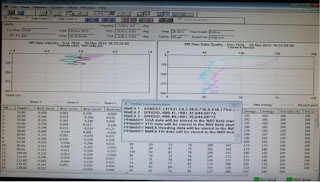
A typical view of the screen of the PCs controlling the ADCP measurements


The measurements from vmadcps when in deep water are calibrated during processing from the bottom track data collected during shallow water transits. Bottom track is basically to measure the heading (position) and speed of the centre of the ship as measured by the ADCP when referenced to the sea floor. It provides the correction estimates on the amplitude and angle for the vmadcp measurements when the bottom cannot be “seen” within the range of the instrument.  Constrained by the maximum bottom track range, bottom track mode can only be working functionally in shallow waters (within the maximum range and also depending on the setup for each instrument).  
The ADCP deck units
 
Apart from the vessel-mounted ADCPs, we also deployed one moored-version ADCP with one of our moorings at the normal offshore extent of the Deep Western Boundary Current (WB4) to collect currents data above the mooring which otherwise would be missing when the mooring is knocked down in strong currents. Two more are deployed at the continental shelf-edge (WBADCP) to measure the currents inshore of WB1.

A self logging version of an ADCP being prepared for deployment before being mounted in a float

Saturday, 28 November 2015

Discovery Friday (Captain Scott's Discovery)

As I write this final instalment of Discovery Friday, we are hove to, waiting for weather to pass to finish our work on the RAPID moorings. The waiting is frustrating but should only be an extra few days—nothing in comparison to the original RRS Discovery, which spent an extra year trapped in ice in Antarctica waiting to be free. 


Captain Scott built his ship from donations to the Antarctic expedition. It was the last wooden ship built in Britain, built by the Dundee Shipbuilder’s Company and launched in 1901. Discovery was built for life in the ice of Antarctica. She had a flat bottomed hull and bow designed to ride up over the ice to break it with pressure. She had a steam engine but relied heavily on sail power to provide sufficient propulsion. The propeller and rudder could be hauled out of the water to avoid damage. Built for the ice, she handled badly in open water and was prone to large rolls.


Scott and his crew set sail in August 1901 and sighted Antarctica in January 1902. They spent a month mapping the coastline before anchoring in McMurdo Sound. They would stay there, trapped in the ice for two years. The idea of being confined in a 50 metre long vessel for two years, trapped in ice, with 47 men would not be something I can imagine enjoying.


The expedition was a success remapping the location of the magnetic South Pole and achieving a record furthest south point of 82º 18’. The ship broke free of the ice in February 1904 and arrived back to the UK in September. The expedition was a success.


The ship took part in various roles for the next 20 years before returning to research and exploration in 1923. It was at this point she was christened a Royal Research Ship, really beginning the lineage that our current ship continues today.


Much like Discovery II would do, this original RRS Discovery spent much of her time in the Antarctic mapping whale populations. This formed part of the Discovery Investigations from which started the Discovery Collections, samples from which are still being used for scientific research to this day.


There are a number of photos and paintings of this old ship on the new RRS Discovery, including two nice watercolours in the conference room. My favourite, however, is in the mess, taken from Discovery’s time as a research vessel rather than her more famous time as Scott’s Antarctic exploration vessel. It shows two men taking sampling with nets over the side. They are clad in gear that you might expect more to be wore by someone on safari in the early 20th Century. Perhaps these were the precursors of the hard hats and safety footwear we wear today. It is a nice picture to finish on as it completes the lineage of scientific research from the original Discovery through to our current home.


Written by Gerard (posted by Darren - slightly late due to a slow connection!)


Friday, 20 November 2015

Discovery Friday (Discovery II)


For me, the most enigmatic of all the Discoveries is Discovery II. I have sailed on the two latest editions of RRS Discovery and read about the first RRS Discovery with Captain Scott in the Antarctic (more about this next week). But Discovery II, built in Glasgow in 1928, is the ship I know least about. It was interesting then that Discovery II features so heavily in the photographs on the bulkheads in the new Discovery.

Discovery II - The first purpose-built research ship


Discovery II is the only ship in the series that seems to have kept its number in the sequence—we don’t refer to our current home as Discovery IV, just Discovery. When it was built, it was the first purpose built research vessel in the world. She was 80m long with a single screw propeller that could notch up a dizzying 13.5 knots! By contrast, the current Discovery has a spec of 12 knots.

Discovery II spent much of her life working in the Southern Ocean. At the time, there was much focus on the whale trade. This lead to a lot of interest in the Southern Ocean. Discovery II did much work on mapping whale populations and krill abundance. She also gathered valuable hydrographic and chemical data from these infrequently visited waters.

The drama of sailing around Antarctica is captured in a number of the photographs on board here. There is Discovery II trapped in the ice while a crewman lies on the ice, ably viewed by 17 other seamen! Or Discovery II sitting in a bay surrounded by snowy mountains. Penguins and the skeletal remains of a victim of the whale trade lie in the foreground.

Discovery II in the ice


Providing scientific support for whaling seems very odd for me as a modern scientist. But in many ways this was the origins of British oceanography. In her later years, Discovery II moved northwards. One of her final contributions was a transatlantic hydrographic section that formed part of the International Geophysical Year in 1957. The important data gathered on that expedition was used near the start of the RAPID project. And formed one of the five hydrographic sections analysed by Harry Bryden and coauthors in a paper in the journal Nature that indicated the Atlantic overturning circulation had slowed from 1957 to 2004. This study provided great motivation for the RAPID project, thus linking Discovery II with what we are doing here and now.

It reminds me of a great quote from Prof. Carl Wunsch in MIT about making observations of the ocean or any part of the climate system. He says that “adequately sampled, carefully calibrated, quality controlled, and archived (observational) data for key elements of the climate system will be useful indefinitely.” And surely this has proved true for the scientists who sailed on Discovery II. 

Discovery II in Antarctica with penguins in the foreground

Written by Gerard (posted by Darren)

Wednesday, 18 November 2015

Talking about the weather


As you'd expect for a British ship many traditionally British things transfer from land to life aboard (like drinking lots of tea). And you couldn't get much more British than talking about the weather. The weather of course has a major influence when at sea and I'm not just on about how likely you are to need the sun tan lotion. The wind and swell conditions are the most important in terms of the ship's motion and thus the ability to do whichever work tasks we have planned.

Today the weather was discussed in more depth than usual with the upshot being that the planned recovery of our WB6 mooring (at 26.5°N, 70.5°W) had to be postponed due to high winds and an increasing swell. So the weather forecasts have been scrutinised (once they could actually be downloaded on our slow internet connection), and with things looking to calm down in a couple of days we sit and wait for now.

Not horrendous, but too bad for the mooring recovery we planned


We're not actually just sitting here doing nothing though - well not just yet anyway. Fortunately CTDs are able to be conducted in worse conditions than mooring recoveries so that's what we're doing today. Most of our CTDs planned for this trip are for moored instrument validation with each instrument being "dipped" before it is deployed on a mooring and again following recovery. And of course we continue with the essential work of processing the data we have collected so far and preparing the equipment for the western boundary moorings - which, aside from WB6, will all be serviced in the last week of the cruise.

Meet the science party (part 5)


Tuesday, 17 November 2015

Biogeochemical sensors added to the RAPID array (part 2)

Biogeochemical sensors and samplers are being deployed at four locations across the subtropical North Atlantic: two are at the western boundary (one at 1500m depth, one at 50m depth), one is on the western flank of the Mid-Atlantic Ridge, and the last is towards the eastern boundary.  At all four locations, oxygen sensors will also be installed at multiple depths throughout the full water column.

Locations of RAPID moorings and where biogeochemical observations will be made.
The largest component of this new instrumentation is the McLane Remote Access Sampler (RAS), which has space to collect 48 unique water samples.

The mechanism by which this happens is quite ingenious. Empty plastic bags (that are slightly more bespoke than a humble 5p carrier) are enclosed within sealed acrylic cylinders filled with water. Over the next 15 months or so, every 11 days an external valve will turn to select a new, unfilled bag port, and start to pump the water out of the bottom of the acrylic cylinder. This will create a pressure gradient within the cylinder that will lead to local seawater being drawn through the sample inlet, through a separate part of the multi-position valve and into the bag. A sample preservative placed in the tubing between the bag and the sample inlet will ensure that the chemistry of the water collected will not change between the time it is sampled and the time at which it is retrieved and analysed. When full, the valve turns back to its home position, and the bag and the water sample it contains become, like a desert island, isolated.

RAS and sensors being deployed at mooring EB1
It sounds so simple but these are quite intricate beasts. Each bag is pressure and leak tested before being evacuated of air; sample lines and cylinders are carefully filled with sample preservative and freshwater respectively before finally over 450 individual fittings are checked, tightened, checked again and probably checked again as we've likely forgotten where we got to. (A few are ok, but with 48 sample bottles it always takes longer to prepare than you think!) Only then will the system be allowed into the water. As can be imagined, this preparation can be a lengthy undertaking but many helpful hands have made light work.

Flower Power: birds-eye view of the multiple tubes leading from the central multi-position valve to individual sample bags / cylinders on the RAS
A number of alterations and additions have been made to the setup that will hopefully bolster its performance. From the extra retaining plates and sensor frames expertly installed by Tom the mooring tech, to the very particular type of plastic chosen for the plastic sampling bags, and the copper-nickel banjo bolts (essentially a bolt with a hole through it) installed at the sample inlet to ward off biofouling and inlet blockage caused by sinking particulates.

Hillbilly Sprinter: banjo bolt water inlet
In the additional frame attached to the bottom of the RAS are located the biogeochemical and temperature/salinity/pressure sensors. Towards the top is located a Seabird Satlantic Deep SeapHOx, a combined temperature, salinity, pressure, oxygen and pH sensor. These are the first of their deep-rated type deployed in anger, and use the same ISFET pH technology as has been successfully used in SOCCOM profiling floats in the Southern Ocean.

Part of the ABC sensor suite: pH sensor (black cylinder, foreground), temperature, salinity, pressure and oxygen sensor (silver cylinder with circular-holed guard, centre-ground), temperature/salinity/pressure sensor (below).
At the bottom of the frame is located the Contros HydroC pCO2 sensor. This uses a small pump to force local seawater past a membrane that is permeable to CO2. Over time, the CO2 in the seawater equilibrates with the airspace that is behind the membrane before being pumped into an enclosed detector and analysed by infrared spectroscopy. In order to stop water vapour condensing within the detector, the internal mechanisms need to be kept at a much higher temperature than the local environment. In the warm and balmy subtropics and for such a long deployment (up to 18 months) this becomes quite a power-intensive process, hence the weighty power pack. Using all the D-cell batteries crammed inside we could have had a remote-controlled car race involving everyone on board ship, and still have a few spare. Note for future cruise: bring remote-controlled cars.

Other part of the ABC sensor suite: Baby Bear (pump), Mummy Bear (pCO2 sensor), Daddy Bear (battery pack)
The final part of the ABC sensor suite is not attached to the RAS frame and is instead installed on the mooring wire, spaced at regular intervals down to the ocean bottom. In total, 24 combined temperature, salinity, pressure and oxygen sensors (Seabird SBE63 ODO mounted on microCAT CTD) will be installed along the four mooring wires where the RAS and other sensors will be located, with a fifth at the western boundary. Together they will create a high frequency time-series of the full-depth transatlantic distribution of oxygen that, as mentioned in part 1, will contribute greatly to an improved ability to estimate the transports of total, natural and anthropogenic carbon, and inorganic nutrients across the subtropical North Atlantic.

Not a flying fish on a zip wire but final part of ABC sensor suite (sort of): a temperature, salinity, pressure  sensor being deployed at MAR1. These are actually part of the RAPID sensors, but additional very similar instruments that have oxygen sensors too have been added for ABC Fluxes (we just don't have a nice photo of them on the wire going into the water!)


Together, the autonomous samplers and biogeochemical sensors provide a substantial chemical upgrade to the successful RAPID mooring array. In 15-18 months time, the data collected should hopefully shed new light on the drivers and processes controlling short and longer-term variability in chemical fluxes, both within the ocean and at the upper-ocean lower-atmosphere interface. But that’s for the future. As yet only two RAS/pH/pCO2/oxygen sensor sets are in the water at EB1 and MAR1, with more still to come at WB4, WBH2 and WB1. Better get to checking some fittings.

Splash: RAS and sensors deployment at EB1


Written by Pete.

Monday, 16 November 2015

Biogeochemical sensors added to the RAPID array (part 1)

For the first time, biogeochemical sensors and samplers are being deployed at selected locations across the RAPID array to help us answer questions regarding the North Atlantic’s part in slowing the onset of global climate change.

As well as being key for the northward transport of heat, the North Atlantic also plays a very important role in the global carbon cycle. Cooling waters and intense biological activity lead to a strong reduction in carbon dioxide concentrations at the surface. CO2 is then absorbed from the atmosphere to make up the deficit, with human-derived carbon (from fossil fuel burning, land-use change, concrete production etc) being absorbed at the same time. This ocean ‘sink’ vastly slows down the increase of CO2 levels in the atmosphere caused by human activities. It’s thus important to understand the processes and drivers of how this happens now so we can better predict how it will behave in the future.

Biological activity in June 2014, observed here through the proxy of average chlorophyll concentration. Note the logarithmic scale and thus the intensity of the activity in the North Atlantic. This is thought to be sustained by the northward transport of nutrients across 24.5°N (black line).


The location of the accumulation of anthropogenic carbon within the global oceans. The North Atlantic holds 20% of the water volume, but 25% of the anthropogenic carbon inventory. Each year, it is thought that approximately half of the new accumulation is transported into the region across 24.5°N by ocean circulation.
Over the last two decades or so, instruments measuring seawater CO2 levels on board volunteer observing ships (such as ferries or container ships) have allowed us to learn a lot about the magnitude of these air-sea exchanges (for instance, the size of the annual North Atlantic carbon sink is roughly equivalent to the annual emissions of the EU, Russia and India combined). However, less is known about the processes that cause it to vary from week-to-week, month-to-month and year-to-year.

A volunteer observing ship, the M/V Santa Maria, travelling between the UK & the Caribbean
It is thought that a large part of this variability is driven by the ocean, with its transport of carbon affecting the surface ocean-atmosphere concentration gradient and storage of anthropogenic carbon, and its transport of nutrients fuelling biology activity. But transport estimates are currently restricted to only every 5 to 6 years when transatlantic research cruises undertake full surveys of deep-ocean physics and chemistry across 24.5°N (which is what the trip after this RAPID cruise will be conducting).

This is where the new biogeochemical sensors and sampling technologies being deployed across the RAPID mooring array are seeking to fill the gaps. As part of the Atlantic BiogeoChemical Fluxes program (www.rapid.ac.uk/abc), oxygen, pH and pCO2 sensors are being installed alongside autonomous samplers collecting water to be analysed for dissolved inorganic carbon, total alkalinity, inorganic nutrients (phosphate, nitrate and silicate) and organic nitrogen.

The biogeochemical sensor & sampler suite ready for deployment at the Mid-Atlantic Ridge
Firstly, these will greatly improve the temporal resolution of observations across the subtropical gyre from once every 5-6 years to once every 4 to 24 hours (for the sensors) or 11 days (for the samplers) - this will allow us to massively increase our understanding of the variability of processes involved in ocean-atmosphere interaction in these locations. Secondly, in combination with the estimates of water transport and the AMOC from the RAPID array, the new measurements will be used to calculate the transport of carbon and nutrients by the ocean at equally high frequency (approximately every 10 days). From here we’ll be able to look much more closely at the role of the North Atlantic in mitigating future atmospheric CO2 increases.

In the next part, we’ll look at bit more at the new technologies being deployed to add a biogeochemical dimension to the RAPID array.

Written by Pete

Saturday, 14 November 2015

Mid-Atlantic Ridge Moorings Completed


We are now effectively two-thirds of the way through the cruise with the last of our moorings on the Mid-Atlantic Ridge recovered and redeployed yesterday. The bathymetry around the ridge poses some challenges to find relatively flat sites of the right depth for the mooring designs. Luckily for us though we have covered these sites many times over the last decade so have very good knowledge of the varying depths for these areas. But essentially we can just deploy the replacement mooring back where we recovered the previous one from (unless we were unable to recover the mooring, which does sometimes happen).

Looking at the swath survey data of these regions now it’s amazing that we managed to find suitable sites back on the original deployment cruise in 2004. On the Discovery of then (see yesterday’s blog post) we only had a single beam echosounder to give us a measurement of the depth in a thin line along the ship’s track. Swath echosounder data gives us a much wider sweep (or swath!) of data so we can see more of the seabed to the sides of the ship track, and on previous cruises we have conducted more comprehensive surveys to build a larger map.

The bathymetry around our MAR3 mooring site. For reference this plot covers an area approximately 10 by 15 miles.
The depth is critical for some of our moorings. Our mooring at the MAR1 site is our longest and covers from 5150m deep to 50m below the surface. As a comparison a 1% error in the wire lengths would put the top of the mooring on the surface where it would be at increased risk from wave motion and passing shipping. A difference of 50m is also considerably less than some of the variations in height that we see on the seabed around our Mid-Atlantic Ridge moorings. So it’s good that we know what to expect at these sites now!

One of my favourite representations of the scale of depth that we are dealing with is shown in the picture below comparing the height of our MAR1 mooring with some well-known buildings.

Our tallest mooring shown against some famous buildings for scale

So now we have a few days until we get to our next mooring site at 70°W. A lot of eyes have been looking over the weather forecasts over the last few days as it at one point seemed that we were going to be facing a bit of a storm as we got to the WB6 site, but the current forecast predicts that this won’t be anywhere near as bad as first thought.

Meet the science party (part 3)


Friday, 13 November 2015

Discovery Friday (Discovery - 1962)

Discovery (1962)


The RRS Discovery that preceded our current home was built in 1962 and served British oceanography for 50 years. During that long time, this Discovery saw a huge change in how science was done at sea. A massive refit in 1992 saw her prepared for modern long oceanographic expeditions. 


Discovery as originally built in 1962
 

Sitting on probably the most modern research vessel in the world, it’s quite hard to imagine how science was done when the old Discovery was built in 1962. For a start, most of the data were gathered on paper. While now I can plug in a 1 TB disk to run from a USB port, the first hard drive fitted on Discovery in the late 1960’s stored up to a limit of 1 Mb (at least I think that’s how big it was—the only spec I could find stated it could hold 512 000 16-bit words, which I think is about 1 Mb). Navigation in those days was done by the stars. This was the world that Discovery began her life in but not how she would end it.

The change in the amount of data and how the data were gathered on research cruises has been immense. Our primary physical oceanography measurement from the ship is a CTD profile. This measures conductivity (from where we get salinity), temperature and depth. We lower the instrument over the side and, all being well, data flows direct to the control computer. In contrast to this, at the beginning of her life, the same measurements were made on Discovery by tying bottles to wires. When bottles were attached to the wire from the ship to seafloor, a messenger weight was sent down to close all the bottles where they sat. This delivered around 24 samples of the water column—a modern CTD makes 24 samples per second. The herald of the new age of continuous sampling came early in Discovery’s life. Cruise 25 saw what was then called a TSD (temperature-salinity-depth) probe. 

Revolutions were afoot in navigation also. Discovery’s first satellite aided navigation system was fitted in the late 1960s. The functionality of these early systems was varied. Even by the mid-1980s, the ship could spend over a month at sea with as little as 400 GPS fixes—the gaps were filled by dead reckoning. This was fine to know where you are going but not accurate enough for many scientific applications. GPS on the current Discovery are accurate now to a couple of centimeters and readings arrive every second.

Discovery (1962) really had two lives: in 1992, she was massively overhauled and ten metres added to her length. This extra space and capability would be needed as she embarked on longer and more remote global expeditions. A prime example is the World Ocean Circulation program that surveyed all the world’s oceans. Discovery played a full part in this experiment, contributing key hydrographic sections.

Discovery (1962) after major refit in 1992


Our project—RAPID—has a particular affinity with the old Discovery. She did more RAPID cruises than any other ship: nine in total. In 2004, Discovery was the ship that deployed the original RAPID moorings. It was fitting then that Discovery’s final scientific cruise in 2012 was a RAPID cruise. This was a special cruise for me as it was my first time being Principal Scientist. We didn’t give her an easy send off. We spent seven weeks working on all the moorings across the Atlantic, doing more than in any other single RAPID cruise. Discovery served us well, she was a great ship. 

Crew, technicians and scientists from Discovery’s last scientific cruise in 2012


Written by Gerard (posted by Darren)

Tuesday, 10 November 2015

A geochemists life during the RAPID Challenge


Having the opportunity to be part of this year’s RAPID Challenge team has given me the chance to step out of day-to-day PhD life and into a modern scientific adventure. My main role on board is to collect seawater samples from a CTD (an instrument suite with water sampling bottles primarily measuring conductivity, temperature and depth - and for this cruise oxygen). The CTD takes a profile (anything from 5800m up to the surface) and then I determine the amount of dissolved oxygen in each sample. 
The CTD being deployed over the side of the ship.
Sounds easy, right? But unfortunately the challenges started immediately. During the transit to Tenerife, I attempted to set up a new titration system in the clean chemistry lab on board. Challenge 1: getting used to the very enclosed, very lonely, very warm clean lab whilst fighting to find my sea legs. Challenge 2: getting consistent results with the titration unit. 
Having failed on both counts, I explored a double plan B: New, spacious, cooler lab; and a different titration unit. Much better! My day starts with chasing all the bubbles out of the sampling tubes in the titrator. So far, this has been a long and frustrating process, struggling to shift smaller bubbles out of the tubes, and generally finding one gets stuck right at the very end of the aspirator (the part of the tube that enters the sample).
Sara using the oxygen analysis kit
Next, I check to see if the titration unit is behaving by measuring numerous “blank” and “standard” samples to make sure the numbers are consistent. The main stage is measuring the real samples collected from the CTD and then plotting the oxygen profile. 
My favourite part is collecting the samples from the CTD (although this is usually done at unsociable hours in the middle of the night). It’s refreshing to go outside, and I always feel a sense of wonder when handling water that was 5km below me only a few hours previously. Whilst filling the glass flasks, we must measure the temperature of the water. This has turned into a game to keep the spirit alive at 3am – whoever guesses the closest temperatures wins a Hobnob. I wish I was better at this game….!

Written by Sara (posted by Darren)